|
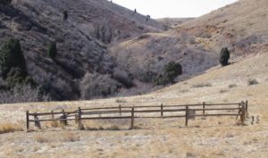
Mount Vernon CemeteryThe town of Mount Vernon is a ghost town now, but in the early days of the Colorado gold rush, it was a serious contender for the state capitol. Of course, in those early days, there were as many contenders for capitol as there were populated areas. What remains of the town is a handful of broken foundations, and the town's small cemetery, all of which are part of the Mathews/Winters Park, a Jefferson County open space area. To get to the cemetery, go to the Red Rocks/Morrison exit off of I-70, (the intersection of highway 40 and I-70). From the parking lot, take the Villiage Walk to the top of the hill (about 0.3 miles). The cemetery is on the right side (west) of the path. There are two fenced areas. In one, there are 5 markers (only 2 non-wooden ones, with legible writing) and in the other there is one simple wooden cross. I failed to get a picture with both of the two areas together. The earliest burial is from 1860, one of the oldest in the state.
|
||||||||||||||||||||||||||||||||||||||||||||||||||||||

